Tag Archives: Google Maps

Southern Colorado Lake

Standard

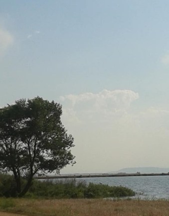
On trips to Colorado, I’ve seen a lake on Highway 159 between Costilla, NM and San Luis, CO. There are no signs at the entrances on Highway 159 naming the lake, but from my research on Google Maps, it appears to be Sanchez Stabilizing Reservoir. The area around the reservoir is Sanchez Stabilization Park; it’s also a Colorado State Wildlife Area.

According to Wikipedia,

Sanchez Reservoir lies in far south-central Colorado, west of the Sangre de Cristo Mountains in Costilla County. Its inflows include Ventero Creek and the Sanchez Canal, a diversion canal that takes water from Culebra Creek and two other creeks…The reservoir’s earthen dam was built in 1912.

I took this photo of Sanchez Stabilizing Reservoir in March of 2020.

Brown signs labeled “Recreation Area” on either side of the highway are the only indication that the lake is on public land and not private property.

There are no signs about camping, nothing to say camping is either allowed or prohibited in the area. I’ve been of the mind that if there’s no sign explicitly prohibiting camping or overnight parking, then it must be allowed. (I find this way of thinking particularly acceptable in the U. S. Southwest. Results may vary in other areas.)

I took this photo of Sanchez Stabilizing Reservoir in the spring of 2017, probably in May.

According to the Colorado Birding Trail website, I was right about camping at Sanchez Stabilization Park. That website says primitive camping is allowed in the Park.

I’ve seen people seemingly camping at Sanchez Stabilization Park in truck campers and small-to-medium pull-behind campers. I’ve typically seen the area more crowded in the summer, but have noticed campers there in all seasons.

The aforementioned birding website also says,

Sanchez Reservoir is among the largest in the San Luis Valley, as well as among the most productive. The southern end can be frustrating to scan; most of the birds are usually on the north end.

The folks at the Colorado Birding Trail say the Reservoir is owned by Colorado Parks and Wildlife and is open all year. The recreation area does not provide accommodations to folks with disabilities, but for birders, some viewing is possible from one’s vehicle.

According to Uncover Colorado

Colorado has 350 State Wildlife Areas, covering more than 684,000 acres. With a valid fishing or hunting license you can access the properties for recreation, including hunting, fishing, hiking and wildlife observation.

I take that to mean that in order to camp at Sanchez Stabilization Park, you need a valid Colorado fishing or hunting license. However, I’ve never seen any notice of such a requirement on site.

According to the Colorado Parks and Wildlife Website, a Colorado annual fishing license for a nonresident over the age of 16 costs $97.97. A one-day Colorado fishing license for a nonresident older than 16 runs $16.94, while a five-day Colorado fishing license for a nonresident over 16 costs $32.14. If you’re a Colorado resident over the age of 16, an annual fishing license costs $35.17. A one-day fishing license for Colorado residents over 16 costs $13.90. Colorado Parks and Wildlife says you can purchase a fishing license in person at hundreds of retailers​ or at a CPW location. You can buy a license by phone by calling toll free 1-800-244-5613​​, or you can buy a fishing license online​.

If you’d rather pay for a hunting license, a nonresident small game one-day license costs $16.75 and an annual nonresident small game license will set you back $82.78. For Colorado residents, a small game one-day license costs $13.90 and an annual small game license runs $30.11. Colorado Parks and Wildlife says you can buy a hunting license in person at hundreds of retailers​ or at a CPW location.  You can buy a license by phone by calling toll free 1-800-244-5613​​, or you can ​​​buy a license online​.

As I was researching this post, I found some references to a Wildlife or Habitat Stamp. At first it seemed that a camper only needed a Wildlife/Habitat Stamp in order to spend time in a Colorado State Wildlife Area such as Sanchez Stabilization Park. However, in a May 5, 2020 Hiking Bob column by Bob Falcone in the Colorado Springs Indy, I learned

…in an effort to make sure everyone pays equally to use SWAs, CPW will be requiring all users to purchase a hunting or fishing license, effective July 1 [2020].

Hiking Bob goes on to say

The least expensive option for Colorado residents would be to purchase a single day fishing license, for $13.90 per day, and the required Habitat Stamp for $10.13 per year. A yearly fishing license can be purchased for $35.17, however senior citizens (over age 65) can get the annual license for $9.85 and are also exempt from the Habitat Stamp requirement.

There are two entrances to Sanchez Stabilization Park from Highway 159. You can take each entrance to several parts of the recreation area. The dirt road leads to the pit toilet restroom at the front of the area, to the tree-lined dirt road where the picnic tables sit in the middle of the recreation area, or to a series of dirt roads that go around the lake.

Pit toilet restroom at Sanchez Stabilization Park near Highway 159. The entrance to the toilet is on the other side.

When I’ve looked in at the pit toilet restroom on a couple of occasions, I’ve always found it fairly clean. Someone is sweeping out the building housing the toilet. There’s usually graffiti on the walls, which is typical in a building that’s probably not attended daily. I must admit, I’ve never lifted the toilet’s lid to find out if anyone is scrubbing down the risers or wiping the seat and lid. While I have seen toilet paper in the restroom, I suggest travelers stay prepared by carrying their own stash of TP.

If the toilet ever gets a thorough scrubbing, whoever does the cleaning must truck in water or haul some from the lake, because there’s no faucet or spigot on site. Again, I suggest preparation if you plan to spend time Sanchez Stabilization Park. Plan to carry in your own water for drinking and washing. I don’t know what might be running off into the lake water, so I don’t know if it’s suitable for washing dishes or the human body. I certainly would not drink it.

While there are no signs saying not to eat fish caught in the Reservoir, the Colorado Parks and Wildlife webpage about Sanchez Reservoir SWA says

Anglers should take note of [the] warning issued by the Colorado Department of Health and Environment regarding mercury levels in fish caught in this reservoir.

Another view of Sanchez Reservoir State Wildlife Area. Photo taken March 18, 2020.

(When I clicked on the link in the above quote on the website, I was taken to an empty link, so I don’t know exactly what the warning says. You can get more information about the Health Department warning in particular or Sanchez Reservoir in general by calling the area Colorado Parks and Wildlife office in Monte Vista at (719) 587-6900.)

These picnic tables at Sanchez Stabilization Park are built to last and resist theft. The benches don’t look comfortable, however.

There are about a half dozen picnic tables in the part of the recreation area between the restroom and the lake. There are stone fire rings near some of the picnic tables,and I’ve never seen signs prohibiting campfires. If you decide to build a fire in this recreation area (or anywhere!), make sure there is no fire ban in effect and please follow Smokey Bear’s Campfire Safety Rules.

There is a line of trees between the picnic tables and the dirt road running behind the picnic area. The trees provide a little shade. Whenever I’ve stopped at Sanchez SWA, I’ve always parked near one of the trees and escaped the sun.

I have seen people camped on the beach next to the lake. After reviewing my photos of the lake, I see that the only trees in the area are the ones near the picnic tables. People camping on the beach don’t have the benefit of the shade trees provide. I bet it gets hot out on that beach in the summer.

This photo was taken from the opposite side of Sanchez Reservoir and shows the line of trees near the picnic tables. I believe this photos was taken in September 2019.

I’m not sure how soft or wet or loose the sand on the beach is. I would be very careful about driving a car on the sand, much less a motorhome. If I were going to pull a rig onto the sand, I would be careful about that too. Before I drove my rig out there, I would walk over the area that sparked my interest and survey the conditions in order to determine if my rig could handle the terrain.

I usually park in the shade of these trees.

Since I haven’t spent a lot of time at Sanchez Stabilization Park and haven’t spent the night there, I’m not sure if bugs are bad out there. They may be worse in the summer (as bugs tend to be). Again, I suggest visitors arrive prepared to keep bugs away.

The lack of signs also mean there’s no indication of how long one is allowed to stay at the reservoir. I looked online, but could find no rules on camping limits at State Wildlife Areas. The upper limit of staying on public land is usually 14 days, so I wouldn’t plan to stay for more than two weeks at Sanchez Stabilization Park.

I don’t know if I would buy a fishing license and Habitat Stamp for the sole purpose of camping at this reservoir. If I liked to fish and didn’t mind throwing back what I caught, it might be nice to spend a week or two here fishing a little and enjoying the peace and quiet.

There’s another way to access Sanchez Reservoir. The Colorado Birding Trail website gives the following directions:

From the intersection of CO 159 and CO 142 in San Luis, head east on the continuation of CO 142 (CR P.6) about three miles to CR 21 and turn right (south). From here it is about five miles south to the SWA.

I took all the photos in this post.

Go See Do: Tips for Finding Fun Out On the Open Road (Guest Post)

Standard

License plate artwork discovered at a Denny’s restaurant, somewhere out on the open road.

Brenda Cordray was one of the first people I “met” through Instagram. I somehow stumbled upon her feed @twentyonefeathers and thoroughly enjoyed her photos, especially the ones of flowers and heart-shaped rocks and other little bits of nature. She and her man are nomads, so I introduced myself and my blog to her and offered her the chance to write a guest post. That guest post is now in front of you. Today Brenda will share her tips for finding fun things to do in the new places you visit whether you’re on vacation or living the life of a rubber tramp.

After 5 years of both solo and tandem road life, I am often asked about boredom. Don’t you ever get bored? I am not a person who experiences boredom. I have often said that I have a rich internal life. I find more than enough things to ponder and consider, especially when I am not stimulated by the hustle and bustle and endless noise of the outside world. I have a dozen projects in the works at any given moment, and many that are sprouting tiny green vines of possibility on a daily basis. The truly creative mind rarely rests.

I have been known to sit for weeks out on the desert in my van all alone. I was perfectly content and never needed the sound of anyone else’s voice for entertainment. Now that I am newly married, my nomadic experience has changed quite a bit. These days I wait patiently for my beloved husband, Dan, to wake up so we can enjoy a good conversation about what we would like to do with this one blessed day that is unfurling before us.

A quick peek out the window reveals our latest sittin’ spot. Sometimes that in itself is a surprise! The scenery outside our windows changes regularly. It takes no effort at all to find things to amuse ourselves out in nature at any given location. We truly are outdoors people, at our best and happiest when we are outside. The outdoors is always fertile ground for exploration, but often we long to venture out into parts unknown to store up precious shared memories.

We aren’t fans of touristy venues, although we have been known to brave the crowds (off-season or on weekdays) to see things that are of keen interest to either or both of us. I love to post pictures of unusual or off-the-beaten-path locales! It is my joy and pleasure to be the navigator, so it falls upon me to ferret out these treasures.

How do I find them, you may ask. Exploration of any area begins with maps.  I love old-fashioned paper folding maps, hefty road atlases, Google Maps, hand-drawn simple maps, or even highly detailed topographical maps that others would have no interest in exploring. All maps are valuable to me. Each has a precious bounty to offer if given the chance to tell its stories.

Stopping at rest area Welcome Centers as you cross state lines is a great way to pick up free and updated folding maps of any state. I replace my old ones often, although the ones that have handwritten notes along the edges and circles and arrows and plenty of Scotch tape holding them together are solid keepers. Racks and racks of glossy travel pamphlets, some with discount codes or coupons, are free for the taking. There are often helpful folks behind the counter who can give more details about local attractions, like whether or not dogs are allowed, or if the attraction you are considering would be suitable for a preschooler or stroller. They are happy that you bothered to ask and are often a wealth of information for the curious traveler.

Statues of American Folk hero, Paul Bunyan and Babe the Blue Ox, located in Bemidji, Minnesota.

Truck stops, restaurants, gas stations, and coffee shops often have racks of pamphlets, too, and local weekly circulars that include calendars full of events and happenings. Many include descriptions of nearby businesses and are a great resource for buy-one-get-one-free meals or discounts on attractions or services.

If I meet a new friend who insists that we go see their home state, or their favorite state, I shush their suggestions long enough to go grab my paper maps and a pencil to mine these priceless bits of information. I often write their names and phone numbers there as well, and where we met, too, since many tell me to call them when we are heading that way because they will have surely thought of more to share.

We are given directions and gate codes from perfect strangers in the event that we venture close to their summer cottage or homestead and would like to stay, even if they don’t happen to be there at the moment. If you are a person of integrity, many will entrust you with prime sittin’ spots. Quite a few will suggest that you stay forever, and it will take your very best efforts to politely disengage and ease on down the road. Those who get out of the house now and again will suggest places of interest for your enjoyment. We are very happy when they give reviews of all the best local restaurants, for days when van-made grub sounds less than appealing.

If you truly enjoy a certain place, stay awhile. Immerse yourself in the ambiance of the area. Strike up conversations with locals. Some of our best travel tips have come from people we may never see again, but will always remember. The places that we have stayed for extended periods of time are often the places we describe to others who are looking for something fun to do. It’s nice to feel that you truly “know” a place you have just left instead of just having a vague recollection of your visit.

Lucy the Elephant, built in 1881, and located at Margate City on the New Jersey Shore.

I am always astounded by driveway surfing hosts who have no idea where the nearest park is or how many truly fascinating things there are to see within a few moments of their home or the neighborhood they grew up in. What fun it is to explore their world and bring it back home to them! Not everyone would enjoy the idea of traveling as much as we do, but one should at least gather up the low hanging fruits of local events and attractions. Weekends aren’t just for chores, people. Recreation is good for the soul and makes the days in between the weekends more tolerable.

When tracing a path from point A to point B, Google Maps is also a great resource. Using two fingers to expand the map uncovers all sorts of fascinating places along your route, and entering a keyword like “museum” can add plenty of depth to the outcome of your search. Even if what you find is not something you plan to do right away, tagging that spot with a star or flag can jog your memory in the event that you venture that way again at a later date.

A Google search of any area being considered should include the top 15 things to do in a few local cities. TripAdvisor offers a detailed list of the most popular sites in any area.The list also includes reviews from those who have been there and have something to say about it. TripAdvisor is usually the first thing that pops up in a Google search. If you scroll down a bit, you may find blog posts, newspaper and magazine articles, Facebook pages, and a variety of links that will flesh out the big picture and lots of smaller details about the area you plan to visit.

Atlas Obscura offers a website that gives you the opportunity to type in a specific location and come away with a list of unusual things to see, like a museum that holds a collection of life and death masks; or the Salt Palace, a museum in Grand Saline, Texas, made entirely of salt. Without this valuable resource, you might pass right by the 200-year-old The Horse You Came In On Saloon in Baltimore, Maryland, whose claim to fame is having served Edgar Allan Poe his final drink. The website includes stories and pictures detailing the history and current particulars about interesting places all around the globe. They also churn out printed books, for those who don’t have to worry about limited space or weight in their chosen road chariot. I carried their book in the van until a fellow nomadic friend who had moved back into sticks and bricks posted that she wanted it badly. I popped it in the mail so she could do a little armchair exploring. Being able to access the same information online is a better choice for me than hauling around a thick reference book.

West Quoddy Head lighthouse at Quoddy Head State Park in Lubec, Maine, the easternmost point of the contiguous United States.

Sometimes I come across interesting places to see in areas we have just left, like the Montague Book Mill, in Montague, Massachusetts. It is said to hold books you don’t need in a place you can’t find. That sounds like a challenge to me, and I love a good challenge!  25,000 books crammed into a 175-year-old building, perched on the banks of the Sawmill River (which holds black river stones smoothed by cold, flowing water) sounds like pure Heaven to me. That one warrants a check mark for next time, and a sigh of disappointment for not discovering it when we were close enough to stop by. At the very least, Atlas Obscura will show you what you are missing right next door, and will give you something to do when you are “bored”, if you are so inclined.

Many of the coolest places we have visited have been the result of serendipitous drive-by discoveries. Once, after taking a wrong turn, we spied a hand-lettered sign that simply said “fort” with an arrow pointing down a backroad outside of Savannah, Georgia. Fort Jackson (the old one, not the modern one) is the oldest brick abutment in Georgia.  It was occupied during three wars, and it protected the city of Savannah during the Civil War. Dan wrote a blog post about our visit.

We spent an entire weekday in this nearly empty fort, enjoying a personal tour given by a newly hatched tour guide who was very excited to share his knowledge.  We were able to really feel the history of the fort without the input of dozens of chattering voices.

We easily took dozens of photos without having to wait for hordes of visitors to move out of the way of the shot. We sat in silence after reading the placards accompanying the displays and deeply considered the sacrifices made by our forebearers to secure this nation’s freedom. We mined the treasures of the museum at our own pace, and felt happy to leave a donation to support the upkeep of this privately funded property because we could clearly see its value. We have seen many historic places defaced by graffiti and feel that if people truly took the time to appreciate them, they could not possibly consider such a heinous crime.

Reading the blog posts of fellow travelers or following their Instagram or Facebook page posts can offer up interesting suggestions as well. We have been honored when our followers have added to their travel plans or bucket lists based on our adventures! You can find literally thousands of photographs of our travels on our Instagram pages, @twentyonefeathers and @fireman428. I love to find free or very cheap places to visit and camp, so be sure to explore the captions below the photos for a plethora of ideas.

Our pups at Camp Wildcat Civil War Battlefield near London, Kentucky, site of one of the Union’s first victories in the Civil War.

I offer these suggestions with the hope that you will find a few jewels through the resources mentioned here, and that you also share your OWN gettin’ spots for unique adventures below in the comment section for others to enjoy. Boredom out on the open road is a mindset that is easily remedied with a bit of creativity and a passion for unearthing hidden spots to explore, both near and far. If you are a weekend or summer holiday traveler and not living the nomadic life, you can squeeze more fun into the time you have available by utilizing a few of these resources. As Dan always says, get out, be safe, and go adventure!

Brenda Cordray is a vandweller who is currently writing a book about her personal journey towards her lifelong dream of nomadic life, and her experiences while living five-plus years out on the road. She is sending out a call to fellow freewheeling souls for interviews about their journey and quest for the nomadic life for possible inclusion in her book. She can be reached at twentyonefeathers@gmail.com. Brenda travels with her husband, Dan, and pups Liberty and Layla, in their repurposed community transport van, Erik van Home.

If you need more ideas of what to do with your free time, see the Rubber Tramp Artist post What Do I Do Now That I Have All This Time on My Hands?

Photos and their captions provided by the author.


Free BLM Camping (Southern New Mexico Edition)

Standard

The Man and I found ourselves in Roswell, NM. When he mentioned he’d never visited Carlsbad Caverns, I said we had to go. I’d been once before, six years ago, with my boyfriend who turned out to be not very nice. Carlsbad Caverns changed me in ways I cannot describe because I can barely understand it all myself. When I realized we were less than 100 miles from a natural wonder The Man hadn’t experienced, I insisted we go.

As soon as we decided to visit Carlsbad Caverns, I got on the FreeCampsites website to try to find us a nice, free place to spend the night.

When my ex and I visited the National Park, we spent the night before our adventure in the parking lot of the Wal-Mart in the town of Carlsbad. I didn’t want to do that if we could help it. First, I haven’t met a Wal-Mart parking lot that wasn’t hot, noisy, and too bright. Why spend the night in a parking lot if we could be out in nature instead? Also, the town of Carlsbad is about 20 miles from the famous caverns, meaning we’d have to start the day with a half hour of driving if we stayed in town. Better, I thought, to drive in the evening and park for the night in a quiet, dark, natural spot.

On the Free Campsites website, I found several options for free camping on BLM land near Carlsbad Caverns National Park. The place I picked doesn’t even have a name; on the website, it’s simply referred to as “Public Lands near Carlsbad Caverns.”

I used the FreeCampsites.net free app on my Android phone to search for promising camping areas. When I decided on the spot where I wanted to camp, I clicked on the “Get Directions” link on the page with the information about the camping area. This link is near the GPS coordinates for the site. When I clicked the “Get Directions” link, it opened up Google Maps which told me how to get from my location to the road where I wanted to camp. The Man taught me it’s better to click the “Get Directions” link than to put in the GPS coordinates myself because I might make a mistake transferring all those numbers. Once Google Maps opened, we let the spokesmodel (I named her Mildred Antwerp) guide us into our spot for the night.

Without Mildred Antwerp to talk us through, it would have been a bit difficult to find the place. I would have had to keep a close eye on my odometer in order to figure out where to turn because the road onto the BLM land not only doesn’t have a street sign, it doesn’t have a name! Google Maps just calls it “Unnamed Road.” There wasn’t even a sign announcing we were on BLM land.

When directed to, we turned off US-180 W/US-62 W onto a fairly well-maintained dirt road. The road was bumpy, but I’ve certainly been on worse New Mexico roads. I didn’t feel as if the van was in any danger.

It wasn’t long before we saw a pull-off–a wide dirt area–on the left side of the road. Farther ahead, we saw other vehicles parked on the left. As indicated in the description of the camping area, we saw a fire ring in the pull-off, not BLM issue as far as I could tell, simply local stones someone had gathered and arranged in a circle. We knew we had arrived.

This pipe snaked on the right side of the road, across from the free camping area.

We didn’t want to park in the first open spot because we like privacy when we can get it, so we continued up the gently climbing road. As we went up and saw other people parked in pull-offs, I worried there might not be a place for us.

All of the camping spots were on the left side of the road. On the right side, I saw a thick, dark pipe snaking across the land. Once we stopped, I was able to read a signpost near the pipe: natural gas. The government owns the land, and somebody’s making money from the sale of the natural gas being pumped out, so I guess the least they can do is let the people camp there for free.

We found a spot, the first unoccupied one past an old pickup with a slide-in camper. The Man backed in the van next to our stone fire ring. We hadn’t brought any wood and there wasn’t any lying around to gather, so we didn’t have a fire that night. We did, however, have a nice view from the back doors.

We were quite far from our nearest neighbor, and we didn’t hear any noise other campers might have made. We were also quite far from the highway and didn’t hear any sounds of traffic. The whole time we were there, only two vehicles passed our camp. Soon after we arrived, a truck drove up the road and not too long after, drove down the road and away. In the morning, a woman who must have been camped above us drove past the van as she left. Otherwise, it was easy to imagine we were the only people in the area.

View from the back of the van

Staying on this BLM land was a true boondocking experience. There was no water, potable or otherwise. There were no toilets of either the pit, the flush, or the portable variety. There were no garbage cans or electricity. It was totally a case of bring in everything you need and take out all the waste you produce. The fire rings were the only indication people had camped there before.

Ocotillo plants and clumps of grass

I did have service for my Net 10 phone the entire time we were on the BLM land. I was even able to post a picture to Facebook and view updates from friends.

I’ve stayed in prettier free camping spots, but this place was not completely lacking beauty. We were in a sort of deserty area with clusters of grass, small cacti, and ocotillo plants growing from rocky ground.  Below us, flat land with no trees stretched as far as my eyes could see. What the area lacked in beauty, it made up for in silence and darkness.

It was also in a great location. In the morning we woke up, ate our cereal and milk, then drove about five miles to the entrance of Carlsbad Caverns National Park. Spending the night on this BLM land beat staying in the Carlsbad Wal-Mart’s parking lot on every count.

The night we stayed on the BLM land, we were blessed with a red moon above us.

I took all the photos in this post.


The Rubber Tramp Artist Rules of Van Life

Standard

#1 Rule of Van Life: Always Know Where Your Keys Are

I’ve misplaced the keys to my van many times. Sometimes I have misplaced the keys by locking them in the van. No good. No good.

My keys on a lanyard long enough to unlock the door without taking it off of my neck.

My keys on a lanyard long enough to unlock the door without taking it off of my neck.

Now my #1 rule of van life if to always know where my keys are. When I’m awake, I wear my keys on a long lanyard around my neck. It’s made from small, pretty blue and green glass beads. I bought it for $1 at a thrift store. I don’t have to take the lanyard from around my neck to unlock the doors, but when I do need to take it off, it lifts right over my head.

When I get out of the van, I make sure the keys are around my neck before I close the doors. It might seem as if I am patting my boobs or belly just for fun, but really, I’m making sure I have my keys. (The challenge is getting the keys immediately out of the ignition and hooked to my lanyard before my attention wanders and I exit the van without my keys.)

When I go to bed at night, my keys are within arm’s reach. If I have to drive the van in the middle of the night, I don’t have to fumble in the dark searching for them. Even when I sleep, I know where my keys are.

Rule #2 Don’t Knock Over the Pee Bucket (When It’s Holding Pee)

I’ve had a variety of pee buckets in my 4+ years as a van dweller. First there was a plastic one-

My current pee bucket with lid.

My current pee bucket with lid.

gallon ice cream tub with lid. Later I used a plastic one-quart, slightly oval shaped ice cream container with a tight-sealing cover. For a while I used a plastic storage container with a snap-on lid with a handle; that container was my favorite, but I lost the lid when I forgot to remove it from the van’s ladder (where it had been propped to air out) before I drove to work. I’m currently using a red coffee can with a snap-off cover.

I’ve knocked the pee bucket over before. While it wasn’t the worst elimination disaster I’ve ever had in the van, it wasn’t pleasant. It was so not pleasant. Now when there’s a container of urine in the van, I am very careful not to kick it or bump it or do anything to make it fall over. I certainly don’t want to drive while there’s pee in my bucket. Even with the cover on, the thing can still leak, and I do not want to deal with urine on the rug and on the floor and on the items on the floor.

Rule #3 Use Blind Spot Mirrors

The Your Mechanic website  says,

No matter how well you position your side view mirrors, there is going to be a blind spot on either side…there will always be areas that you cannot see. Blind spot mirrors are designed to alleviate this problem.

I swear by blind spot mirrors. I don’t know why all driver’s aren’t using them, whether on a van or a pickup truck or a sports car. They are inexpensive; a two pack usually cost under $10 at Amazon, auto supply stores, or any store with an automotive department. They are easy to install by peeling away paper backing covering the strong adhesive on the non-mirror side. Press the blind spot mirrors to a clean (cleanliness is crucial for proper sticking) side view mirror and get ready to see everything in your blind spot that you have been missing.

Rule #4: Do Your Routine Maintenance

Get your oil changed regularly. (The Your Mechanic website recommends every 5,000 to 10,000 miles). Check the air pressure in your tires and add air as needed. Check your fluid (oil, brake, transmission, coolant/antifreeze, power steering) levels and add accordingly. Take care of problems before they become disasters.

Rule #5: Carry Basic Automotive Supplies

I have a pair of jumper cables in my van. I believe everyone should carry jumper cables, especially if traveling to areas where it might take a long time/be impossible for roadside assistance to get to you. It’s usually fairly easy to find a helpful person to give your battery a jump start, but helpful people don’t always have jumper cables.

In addition to jumper cables, I have a jack and a tire iron. I also typically carry brake fluid, oil, and antifreeze/coolant.

Rule #6: Don’t Hit the Road Without a Paper Map

Sure, sure, GPS systems and map apps are great–if they work. I did a Google search on “did people really drive off cliff while following GPS” and came up with a whole list of GPS disaster stories. GPS systems really do lead people astray. img_7800

I’ve never used GPS, but I do tend to rely on Google Maps. I use Google Maps on my laptop to map out routes in unfamiliar cities, and I use it to decide how to get from a city (or nature area) to my next destination. Several times while traveling in California, Google Maps has directed me to roads that don’t exist or sent me well out of my way.

On a couple of occasions, I’ve been able to pull over and use the Google Maps app on my phone to recalibrate from my current location. But recently, after Google Maps sent me on a wild goose chase–out of my way–hour long–gas guzzling–circular excursion, I stopped at a gas station to figure out what I should do from there. Google Maps told me what to do, but I immediately realized it was all wrong. Highway 49 was not the same as Main Street, and the directions told me to go the same way from which I’d just come. So I pulled out my atlas and figured out where I was and where I wanted to be. Turns out a nearby highway was a straight shot from point A to point B. If I had looked at the paper map before I hit the road, I would have seen that Google Maps had sent me on a route that was never going to take me where I wanted to go

Rule #7: Stock Up on Essentials Before You Leave Civilization

Before I head out to a remote area, I make sure I have everything I need. Even if I can find a store in a small town selling the necessity I’ve forgotten, I’m going to pay more for it in a remote location. These are the essentials I make sure I have before I head out of Babylon: food, water, ice, propane, toilet paper, paper towels, soap, wet wipes, gasoline.

Rule #8: Tell Someone Where You Will Be

I have a trusted friend I text everyday if I have cell service. Before I hit the road, I tell her where I’m going. When I arrive, if I have cell service, I text her to let her know I am safe. If I change my plans, I alert her. If she doesn’t hear from me, she checks in. I know doing this won’t save me if someone decides to hurt me, but I feel more confident knowing someone will realize pretty quickly if I disappear and be able to direct a search party to a starting point.

Rule #9: Bungee Cords Are Your Friend

I’ve spent a lot of time picking up plastic drawers and tubs (and their contents) from the floor of the van. Rapid braking and sharp turns made my belongings tumble to the floor. Now I’ve got my stuff tied down with bungee cords. I buy the cheap ones, as they don’t really have to be super strong. They just have to be strong enough to keep my life from flying around as I drive.

Rule #10: Don’t Forget to Have Fun

Having fun is one of the reasons we’re doing this van living stuff, right? We get to travel and see amazing places. We get to explore because we’re not tied down, not spending a huge portion of our money on rent. So don’t get so uptight and worried about what might go wrong that you forget to have fun. In my experience, a bit of prior planning (maintaining the vehicle, strapping down with bungee cords, knowing where my keys are) allows me to relax, arrive safely at my destination, and have a good time while I’m there.

ol-betsy

I took the photos in this post.

What are your rules of van life/life on the road? Feel free to share them in the comments section below.

Saddle Mountain

Standard

IMG_5146I first heard about the Saddle Mountain BLM (Bureau of Land Management) land at the 2015 Rubber Tramp Rendezvous. I ran into a guy I’d previously met in New Mexico, and he told me about the BLM land surrounding Saddle Mountain, but I didn’t make it out there before I set out for my summer job. In early winter 2016, my friend Coyote Sue took a trip to the area, and I decided I REALLY wanted to go there.

IMG_5179One reason I hadn’t gone sooner was because I didn’t have very good directions. The guy who first told me about the place pointed to it on an old Arizona map, but he wasn’t able to tell me what roads to take. I was a little worried about going out there and getting myself lost. Before I set out on my trip, I did some research by searching “saddle mountain free camping Arizona” on Google. I got a hit on the Free Campsites website.

On Free Campsties I found the GPS coordinates (33.458626, -113.055023) and plugged those right into Google maps.  (Thanks Google!)

I’ll just go ahead and give directions so nobody has to do all that work him/her self.

From Interstate 10 in Arizona, take exit 94 toward Tonapah. Turn left onto 411th Avenue. Keep  going south for almost three miles, passing Osborn Road and the Saddle Mountain RV Park. You’ll get to a T in the road. Turn right onto West Salome Highway. (If you go left, you will end up in Buckeye, AZ.) Drive for 5.2 miles, then turn left onto Courthouse Road. Both West Salome Highway and West Courthouse Road are paved and both have official street signs. After 1.8 miles on West Courthouse Road, turn left onto the Saddle Mountain BLM land. IMG_5172

Like a dumbass, I had not written down the distances I was supposed to go on each road. I found Salome Highway easy enough (411th Avenue ends, go left or right, no big deal), but I’d gotten a little worried after a couple of miles that Courthouse Road wasn’t signed, and I’d missed it. I kept going, then saw the sign for Courthouse Road and breathed a sigh of relief. I wasn’t lost. However, because I didn’t know how far I was supposed to go on that road and my last direction was simply “turn left,” I didn’t know where to turn onto BLM land.

I drove slowly and kept an eye to the left, hoping to see a sign. I didn’t see a sign, but I did see a kiosk. IMG_5132Although I couldn’t read the words Saddle Mountain on the top of the kiosk, I suspected I was in the right place and turned down the road. When I got closer and read the words up there, I knew I’d made it.

The kiosk didn’t have any information on it, other than one sign saying this is a pack-in/pack out area. (There are no amenities in this area, not even a trash can or a pit toilet.)

I drove south on the road, which I later found out is Route 8211. IMG_5169This road is not paved, but is what I would describe as a “good” dirt road. My conversion van had no trouble getting down it.

As I drove down Route 8211, I saw one RV, an older, medium size motor home which was about to pull out of its spot. The people in it waved to me as I drove by. During the time I was there (Wednesday afternoon to Saturday morning), I didn’t see any other folks camping in the area.

As I was trying to find a spot, I realized I could see bits of civilization to the north. Sure, I wasn’t looking at a metro area, but I could see vehicles (including many 18-wheelers) driving past on I-10. I could also see a couple of large industrial operations between my location and the interstate. I decided to park the van so my side doors opened to the south, which offered a view of mountains and cacti, not the trappings of humanity.

IMG_5137Once the sun went down, I could see a good number of ligths to the north and the northeast, which also detracted from the sense of being alone in the wilderness. Sure, Saddle Mountain is well out of the city, but I didn’t feel as if I were in the middle of nowhere. IMG_5142

That situation might have been remedied if I had driven farther down Route 8211. On Friday evening, I went for a walk to the south on that road and found many other places where folks had obviously boondocked before. There were plenty of flat spots to park a rig, and I saw fire rings made from rocks obviously gathered in the area.  I didn’t move the van; I was much too lazy for that. However, next time I stay there, I will drive to the end of the road and try to find a place where I can’t see one bit of civilization.

Although I could see vehicles on the interstate, thankfully, I couldn’t hear them. I didn’t hear much human noise out there. The sound  of a car engine passing on the road in front of the van did wake me up on Wednesday night. When IMG_5171I looked at my watch, I saw it was 11:30. I thought it was a weird time to go exploring, but whatever. I heard the car pass by again, headed to the main road, before too long. On Thursday morning, a couple and their dogs walked on the road in front of the van; the woman and I waved at each other. Several hours later, they walked past again, going back to their vehicle, I assume. On Friday the sound of a man and a little boy walking by caught my attention, but other than those situations, maybe two other cars driving on Route 8211, and a few aircraft flying overhead, I only heard the sounds of nature.

I absolutely enjoyed my time in the Saddle Mountain area, and hope to stay there again.


IMG_5150

I took all of the photos in this post. They were all taken in the area around where I camped near Saddle Mountain.