Tag Archives: Raton Pass

The Last Rest Area in New Mexico

Standard

The Man and I were in Las Vegas, NM, and we decided to go to Trinidad, CO. We got on I-25 and headed north.

It was late afternoon by the time we got started, and I was tired of driving well outside of Raton. I knew we had the Raton Pass ahead of us, and I didn’t want to make that mountain crossing in the dark. I’d looked at the map before we left Las Vegas and seen the last rest area in New Mexico on I-25 was less than twenty miles south of Raton. I needed to pee anyway, so I decided to stop at the rest area and check it out.

I knew there was a Wal-Mart in Raton, and we could probably park there overnight. However, I wanted to cook dinner, and I always feel weird cooking in the parking lots of stores. Even if we decided not to spend the night at the rest area, we could certainly cook dinner there. No one tends to blink an eye at people having a picnic at a rest stop.

I pulled into the reast area on the east side of the highway and found a spot to park. I walked briskly to the toilets while The Man took the dog out. The restroom was really clean, with flush toilets and sinks complete with running water for hand washing.

When I went back outside and had a better look around, I realized everything in the rest area was really clean. There was no litter on the ground and no graffitti.

In addition to the building housing the restrooms, there are several covered picnic table there.  The picnic pavillions have low stone walls to block the wind and there are many trees throughout the rest stop, making the area pretty and providing shade.

As I looked around, I saw The Man and the dog in a flat, treeless area at the back of the rest area, so I walked out to meet them. Beyond the flat area were train tracks. As we stood there, we heard a train a comin’. It got closer, and I saw it was an Amtrack.

It’s a people train! I exclaimed. I stood tall and waved vigorously as the train passed. I couldn’t tell if anyone waved back–or if indeed there were passengers on the train–but I had a great time waving and imagining  passengers wondering who I was and why I was there.

We walked back to prepare our dinner of eggs and cheese and onions and zucchini on tortillas. We decided to cook next to the van instead of hauling all our supplies and equipmemt down to one of the picnic pavillions. In minutes, we had a table and our stove set up, and onions were sizzling in our cast iron skillet.

After eating and doing my share of the cleanup, I didn’t want to drive anymore. Let’s stay here tonight, I suggested, and The Man agreed.

While the rest area is developed and well-lit, it seemed better than a Wal-Mart parking lot. Maybe the trees helped. Maybe it wasn’t quite so hot because there wasn’t so much asphalt. Maybe I was just dog tired. In any case, I slept well, despite the idling big rigs parked rigth behind us and the comings and goings of drivers who needed to stretch their legs or take a bathroom break in the middle of the night.

In the morning, I snapped a few photos. I’ve noticed there’s often at least one historic marker at New Mexico rest areas. This stop has a marker with information abouth the nearby Clifton House site. According to Wikipedia,

The Clifton House was an important overnight stage stop on the Mountain Branch of the Santa Fe Trail. It was located in Colfax County, New Mexico about six miles south of Raton, New Mexico, on the Canadian River. The site is located at mile marker 344 of U.S. Route 64, just off of exit 446 on Interstate 25.


The other side of the marker shows a “Points of Interest” map of the area, and I saw we were quite close to the mountain branch of the Santa Fe  Trail. Neat!

When I finished taking photos, I found The Man and the dog were ready to go. I climbed into the driver’s seat, and we headed to Raton in search of coffee.

We crossed the Raton Pass and stopped at the scenic overlook on our way to Trinidad.

I took all the photos in this post.


Raton Pass Scenic Overlook

Standard

I was driving. We were headed north on I-25, on a spur-of-the-moment trip from Las Vegas, NM to Trinidad, CO.

I’d been on this stretch of interstate once before, but I didn’t remember too much about it. The Man kept talking about the beauty of the Raton Pass. He was excited to see it again.

According to Wikipedia,

Ratón Pass (7834 feet or 2388 meters elevation) is a mountain pass on the ColoradoNew Mexico border in the western United States. Ratón is Spanish for “mouse.” It is located on the eastern side of the Sangre de Cristo Mountains between Trinidad, Colorado and Raton, New Mexico, approximately 100 miles (160 km) northeast of Santa Fe. The pass crosses the line of volcanic mesas that extends east from the Sangre de Cristo Mountains along the state line, and furnishes the most direct land route between the valley of the Arkansas River to the north and the upper valley of the Canadian River, leading to Santa Fe, to the south.

The pass is a historically significant landmark on the Santa Fe Trail, a major 19th-century settlement route between Kansas City, Missouri and Santa Fe. It was designated a National Historic Landmark in 1960 for this association.

The Raton Pass is at an elevation just over 7,800 feet.

The really beautiful mountains were to the west. They were snow covered and wonderful. I wanted to see more of them.

Can we stop? Can we stop? Baby, can we stop? The Man chanted.

He’s been known to pull off on the shoulder of the road–any road,  highway, interstate, any road–to take a photo. I’m a bit more safety conscious. I don’t like to stop on the side of a busy interstate or a curvy mountain road (or a curvy mountain busy interstate), but I will, it that’s the only way to get a photo the man or I (or both of us) want. In this case, I’d seen a sign for a scenic overlook and decided it would be much safer for us to stop there.

Scenic overlook, Baby, I told him. We’ll stop at the scenic overlook.

I took the scenic overlook exit and was tremendously disappointed to find we could not see the huge, snow-covered mountains.

Why didn’t they put this overlook where we could see those other mountains? I asked rhetorically.

Oh well, the scenery seen from the scenic overlook was lovely. The Man and I stayed about ten minutes, taking photos of the land and each other, then got back on the road. We were soon in Trinidad.

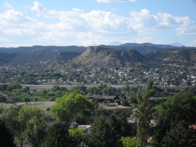
Panoramic view from the Raton Pass Scenic Overlook

You can read more about the Raton Pass and its history.

I took all of the photos in this post.


Trinidad, Colorado

Standard
SDC10020

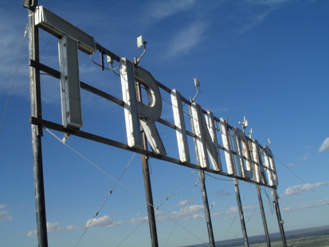
This sign is on a bluff on the Northern end of Trinidad. The bluff is called Simpson’s Rest, and is named for early resident George Simpson, who is buried there. The sign is lit at night so folks don’t have to wonder where they are. My friends and I took North Avenue, which leads to a rut-prone county road to the top of Simpson’s Rest to visit the sign and look down onto the town. I took this photo while we were there.


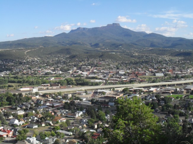
This is the view of Trinidad from the mountain/hill where the big Trinidad sign stands.

This is the view of Trinidad from Simpson’s Rest, where the big Trinidad sign stands. I took this photo too.

I took a trip to Trinidad, Colorado to visit friends who had moved there from Austin, Texas.

Trinidad is a small town (population 8,465, as of 2013) in Las Animas County, Colorado. It is the most populous town in the county and the county seat.

Trinidad is situated in the Purgatoire River valley in far southern Colorado at an elevation of 6,025 feet (1,836 m). The city lies 13 miles north of the New Mexico border.

Trinidad bricks. Photo by me.

Trinidad first became a town because of the Santa Fe trail. The town grew as a resupply stop on the Santa Fe trail. In 1862, coal was found in the region and lots of people (primarily immigrants) flocked to the area and to Trinidad to work in the mines and make money off of the people who worked in the mines.

When I told a friend in Northern New Mexico that my Austin friends had moved to Trinidad, he only wanted to talk about sex change operations. From Wikipedia:

Trinidad was dubbed the “Sex Change Capital of the World” because a local doctor had an international reputation for performing sex reassignment surgery. In the 1960s, Dr. Stanley Biber, a veteran surgeon returning from Korea, decided to move to Trinidad because he had heard that the town needed a surgeon. In 1969 a local social worker asked him if he would perform the surgery for her, which he learned by consulting diagrams and a New York surgeon. Biber attained a reputation as a good surgeon at a time when very few doctors performed the operations. At his peak, Biber was performing roughly four sex change operations a day, and the term “taking a trip to Trinidad” became a euphemism for some seeking the procedures he offered. His surgical practice was taken over in 2003 by Marci Bowers. Biber was featured in an episode of South Park where elementary school teacher Mr. Garrison undergoes a sex change operation. Dr. Bowers has since moved the practice to San Mateo, California. The 2008 documentary Trinidad focuses on Marci Bowers and two of her patients.”

Here's a view of Simpson's Rest from the other side of town. You can see just see the Trinidad sign, which is tiny in this photo that I took from the Ave Maria Shrine.

Here’s a view of Simpson’s Rest from the other side of town. You can see just see the Trinidad sign, which is tiny in this photo that I took from the Ave Maria Shrine.

Also from Wikipedia:

For many years Trinidad housed the miners who worked in the coal mines of the Raton Basin south and west of the town. The coal mines are now closed, but since the 1980s companies have been drilling new gas wells to extract coalbed methane from the remaining coal seams.

Trinidad’s location at the foot of Raton Pass, along the Santa Fe Trail between St. Joseph, Missouri and Santa Fe, New Mexico, has always made it a favored route for travellers, first by foot, then horse and ox-drawn wagon, then by railroad. Today Interstate 25, the most highly traveled route between Colorado and New Mexico, passes through Trinidad, and was recently reconstructed through the city to upgrade the aging raised viaduct in which the highway used to go through city.

I used the Wikipedia article about Trinidad quite a bit to jog my memory and find statistics about the town.

I took all of the photos in this post.