Tag Archives: Tohono O’odham

Picnic Area

Standard

We’d left Truth or Consequences later than we’d planned. Then we’d made a couple stops in Las Cruces (breakfast, guitar strings), so the sun was low in the sky as we drove through Tucson. When we turned onto Highway 86 West (also known as Ajo Way), I was disappointed to see a sign declaring we were still

Crested Saguaro

over 100 miles from Ajo. Not only was I tired of driving, but I was afraid driving in the dark would mean we’d miss the two crested saguaros Coyote Sue said were visible from Highway 86.

The Man and I discussed what we should do. Push on and drive into the night, missing the crested saguaros? Find a place to park for the night and see the saguaros in the morning? We decided we wanted to find a place where we could park the van and sleep until first light.

We were soon on Tohono O’odham land. According to Wikipedia,

The Tohono O’odham (/tˈhɑːnə ˈɑːtʊm/, or /tɑːˈhnə ˈɑːtəm/)[2] are a Native American people of the Sonoran Desert, residing primarily in the U.S. state of Arizona and the Mexican state of Sonora. Tohono O’odham means “Desert People.” The federally recognized tribe is known as the Tohono O’odham Nation.

The Man kept pointing out places where he thought we could park the van for the night, but I was hesitant to park randomly on the reservation. Although we had nothing to hide from the police, nothing spoils a good night’s sleep like a cop knock in the dark. (If we were ever parked somewhere and a cop knocked in the night, I would simply tell him or her that we were too tired to drive safely, and we’d move on at first light.) Also, I didn’t want to be the white person who thinks she’s entitled to do whatever she wants on native land she knows little about.

Picnic Area on the south side of Hwy 86

I kept driving, and I really was getting to the point of feeling as if I just couldn’t go much father. Then, between mileposts 136 and 137, on the south side of the highway, I saw a picnic area. I pulled in and saw no signs prohibiting overnight parking or even camping. Here it was! This was our spot for the night!

There wasn’t much to the picnic area. There were a few picnic tables there, a shade cover over a few of them. There were no restrooms and not a single trash can. No problem! We only needed to stop for the next six or eight hours.

A fence separated the picnic area from the reservation, but we were too tired to even consider crossing. All I had on my mind was sleep.

When we first lay down, we heard a lot of traffic on the highway, It was a Friday night, and I think people were heading home from their jobs in Tucson, while others were heading to Tucson to party. As the hour grew later, we heard fewer cars on the road, and we slept peacefully.

In the background of this photo, one can see the fence separating the picnic area from the reservation.

The next morning as we stretched and brushed our teeth, The Man noticed an observatory on top of a nearby mountain. Within an hour we passed an entrance road and a sign declaring it the Kitt Peak National Observatory. We didn’t stop, but according to Wikipedia,

The Kitt Peak National Observatory (KPNO) is a United States astronomicalobservatory site located on 2,096 m (6,880 ft) Kitt Peak of the Quinlan Mountains in the ArizonaSonoran Desert on the Tohono O’odham Nation, 88 kilometers (55 mi) west-southwest of Tucson, Arizona. With 24 optical and two radio telescopes, it is the largest, most diverse gathering of astronomical instruments in the world.[1] The observatory is administered by the National Optical Astronomy Observatory (NOAO).

At the very peak of the mountain, something related to the Kitt Peak Observatory is visible.

Roadside America says the Visitor Center is open daily 9-4 (call 520-318-8726 to verify). Admission is free, but one-hour guided tours cost $8.00-$10.00 per person. According to bobebob on 01/25/2015,

The best views of the complex are from the outdoor catwalk around the Mayall telescope, whose 15-ton mirror is housed in a dome 18 stories high.

Picnic table and tree

On Saturday, we spent time with the Diving Miss M, and sometime during our conversation, she mentioned the Arizona Department of Transportation has a 12-foot easement on either side of Highway 86. The land past the easement is part of the reservation. Being left alone at the picnic area made sense. The picnic area is on the easement, which means ADOT maintains it. Surely no ADOT employee was patrolling the area at night to run off sleepy travelers. Tribal police probably aren’t very concerned with what happens at the picnic area since it is technically the ADOT’s jurisdiction. I suppose someone from the Pima County Sherriff’s Department or the Highway Patrol could have questioned us if a complaint had been lodged or if we’d been causing trouble, but we were sleeping, not drinking or yelling or even littering. If an officer of the law saw us parked at the picnic area that night, s/he decided we weren’t worth stopping for. Personally, I was grateful for uninterrupted sleep.

I took all of the photos in this post.


Ajo Murals

Standard

During my first trip to Ajo, AZ, I saw a few murals on the south side of the Plaza when I drove by on Highway 85.

This is the one I saw the most often:

IMG_5579

I love the way the clouds and blue sky in the photo mirror the clouds and blue sky in the painting.

It faces the highway and is quite obvious. I saw it whenever I drove south past the Plaza.

This is the mural I saw as I drove north past the Plaza:

IMG_5581

IMG_5582

This is the mural to the left of the one with the coyote and the saguaro. The quote, attributed to Gandhi reads, “The best way to find yourself is to lose yourself in the service of others.”

During my second trip to Ajo, I decided to take photos of these two mural and the one to the immediate left of the one with the coyote and the saguaro, which I could just barely see when I drove by. As I stood at the entrance to the alley, I was quite surprised to see many murals painted on the walls on both sides.

As far as I remember, no one I met in Ajo or Why told me about this collection of murals. The lady in the thrift store didn’t mention it. I didn’t see any brochure about it at the visitor information center. Did Coyote Sue tell me about it and I forgot? I tend to enjoy looking at public art, so it seems to me if someone had mentioned these murals as an Ajo attraction, I would have gone to look at them right away.

When I did a Google search on “Ajo alley murals” (or something to that effect), I found an entry from April 6, 2015 on the Tucson Mural Arts Program blog. The date on this post shows the murals are fairly new.

At the top of the aforementioned blog post, there is information about the  Tucson Mural Arts Program.

The (TMAP) seeks to create a city wide outdoor gallery of original artworks by matching artists with wall owners. TMAP is a results-based beautification program that involves residents of all ages in the design and painting of murals. We offer a viable solution to social isolation and property damage by working with our community to collaboratively create works of art.

IMG_5587

I’m not sure if this stencil art is an officially sanctioned, but it’s in the alley, and I like it. I’m amazed by the depth of expression in the man’s face.

The blog entry, titled “Ajo Street Art Mural Project,” says,

Muralists from Tucson joined with artists from throughout the border region helped to enliven an alley between two historic warehouse buildings in the heart of the Sonoran Desert, Ajo, AZ.

Artists spent a week painting murals throughout the day and night creating a festival like atmosphere in the once barren alley way.

The blog posts shows “before” photos of the alley, as well as photos of the artists at work.

The post continues,

…Arts Brigade artists had a ton of fun working with the local high school students and their teacher. Students created a series of individual and group murals. TAB [Tucson Arts Brigade] artists taught students the basic tools and techniques needed to make a mural.

IMG_5596

The TMAP website identifies this piece as “Alice Glasser Mural.” Alice’s signature is on the lower left of the piece.

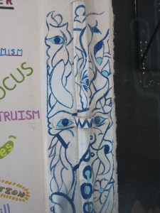
IMG_5602

This is one of my favorite pieces in the alley. I appreciate the way the pipes and the breaker box seem to disappear into the art. I wish I could hear the music these men would create. Who is Don? Is he one of the men represented here? And who is the artist? (I don’t think I cut the artist’s signature out of my photo, but that is a possibility.)

I’m surprised the town of Ajo or the International Sonoran Desert Alliance or TMAP or somebody hasn’t produced a brochure giving information about each piece. This art is beautiful and important and deserves to be seen. Is there such a brochure and I missed it? How could I have missed such a thing?

IMG_5604

This mural made me sad because it’s been sketched out but never completed. What happened to the artist(s) who started this piece? Will it ever be finished?

IMG_5588

I like that not all of the murals show off lofty themes or extraordinary artistic talent. This mural is by and for the people.

In any case, I was glad I stumbled upon the murals. In a way, it was more magical to find them on my own. I found them because I was paying attention, not because I saw it on a list of things tourists should do or because some guidebook or website or brochure recommended it to me.

I documented the whole alley, and now you can have a look at the art and decide on your favorites. (Feel free to write a comment to tell me which piece is your favorite and what you like about it.) I took all of the photos in this post, but of course, my photos never truly do justice to the subjects. IMG_5608


IMG_5583

IMG_5584

I tried to move the piece of metal visible on the bottom right of this photo so I could capture the full mural, but the metal was HEAVY. I enjoy the juxtaposition of the soothing blues and greens of the art next to the utility pole and the old door.

IMG_5586

There is so much to love in this piece: the person composed of the yin-yang symbol, a heart, a peace sign, and the infinity symbol; the landscape with mountains, trees, and cacti; the reminders that “all life is sacred” and “end racism.”

IMG_5592

The edge of this piece is visible on the left of the previous photo. I like the way this piece blends in to what’s around it.

IMG_5591

If you don’t know Spanish, “eres el sueño” means, “you are the dream.”

IMG_5589

Hometown pride…

IMG_5593

IMG_5594

IMG_5595

IMG_5600

I believe this piece represents the of three nations of the Sonoran Desert – the U.S., the Tohono O’odham Nation, and Mexico.

IMG_5601

IMG_5603

This piece is equating pre-unification Germany with the the Tohono O’odham Nation, which has been divided by the border between the U.S. and Mexico. From the Tohono O’odham Nation website: “From the early 18th Century through to the present, the O’odham land was occupied by foreign governments. With the independence of Republic of Mexico, O’odham fell under Mexican rule. Then, in 1853, through the Gadsden Purchase or Treaty of La Mesilla, O’odham land was divided almost in half, between the United States of America and Mexico… the new border between the United States and Mexico was not strictly enforced…In recent years, however, the border has come to affect the O’odham in many ways, because immigration laws prevent the O’odham from crossing it freely.

IMG_5606

The TMAP blog post identifies this piece as “Kat’s Mural, ‘Heart of the Desert’.”


IMG_5609

The TMAP blog identifies this piece as “Doors of Perception” and says it is “by Valeria and Isabella H. (TAB [Tucson Arts Brigade] youth artists).”

IMG_5610 IMG_5614


IMG_5612

IMG_5617

IMG_5618

The TMAP blog post identifies this piece as ‘Flip.” It was painted by Michael Schwartz.

IMG_5624IMG_5623


IMG_5619

I find this mural so moving. It depicts the work of The Ajo Samaritans, a humanitarian aid group that works to prevent death in the desert by leaving food and water for travelers walking through the harsh terrain.

IMG_5621

The words in Spanish say, “Take them if you’re thirsty.”

I took all of the photos in this post.

Ajo, Arizona

Standard
IMG_4873

This “Welcome to Ajo” tile mosaic is on Highway 85, just south of the Olsens Market Place grocery/hardware combo store. I don’t know who created this mosaic, but I like it a lot.

My friend Coyote Sue spends part of her year in Arizona, around the towns of Ajo and Why. She invited me to visit the next time I was in the area. When I left the 2016 RTR (the Rubber Tramp Rendezvous–read more about it here: http://www.rubbertrampartist.com/2016/01/23/report-on-the-2016-rubber-tramp-rendezvous/), I decided to drive down to Ajo to visit Coyote Sue and do a bit of exploring.

IMG_4792

This is “A” Mountain–official name, Camelback Mountain–in Ajo, AZ. The elevation of this mountain is 2,573 feet. I believe I was on Indian Village Road when I took this photo. I was definitely on my way to the history museum when I took it.

According to https://en.wikipedia.org/wiki/Ajo,_Arizona, Ajo

 …is a census-designated place (CDP) in Pima County, Arizona… The population was 3,705 at the 2000 census. Ajo is located on State Route 85 just 43 miles (69 km) from the Mexican border. It is the closest community to Organ Pipe Cactus National Monument.

If you thought, as I did, that Ajo was named for the Spanish word for garlic, you would be, as I was, wrong. Although the DesertUSA website (http://www.desertusa.com/cities/az/ajo.html)–which doesn’t site any sources–says,

In Spanish, ajo means “garlic.”  Wild garlic plants (the Ajo lily or desert lily – an onion-like plant) that grew in the surrounding hills were responsible for the naming of the community…

I’m more inclined to believe the explanation on the Ajo Chamber of Commerce history webpage (http://www.ajochamber.com/explore/history-of-ajo/).

Before the community of Ajo was settled, the Tohono O’odham [the local indigenous people] used water from a series of potholes in the area they called Mu’i Wawhia or Moivavi (many wells). Mexican miners later called the site Ajo, perhaps influenced by another O’odham name for the area –-au-auho—for the pigment they obtained from the ore-rich rocks.

Ajo exists because of mining. The aforementioned Chamber of Commerce history webpage details the history of Ajo and mining. I’ll cover that information when I write about my visit to the New Cornelia Open Pit Mine Lookout.

Ajo has a lovely town plaza.

IMG_4704According to http://www.ajochamber.com/attractions/local-attractions/, the plaza

IMG_4699

This photo shows the Immaculate Conception Catholic Church, which is west of the Ajo plaza.

IMG_4707

This photo shows the Ajo Federated Church, which is west of the Ajo plaza.

was built in 1917 under the direction of John Greenway’s wife Isabella. The Spanish Colonial Revival style town square features a center park surrounded by retail shops, a post office and restaurants accented with two mission-style churches. The [Immaculate Conception] Catholic Church was built in 1924 and the Federated Church in 1926…The plaza was purchased by the International Sonoran Desert Alliance in 2008 and is in the midst of a multi-year process of restoration and revitalization.

IMG_4569

This photo shows Immaculate Conception Catholic Church and mountains. I appreciate the crisp whiteness of the churches against the starkness of the mountains.

According to http://www.desertusa.com/cities/az/ajo.html, the Immaculate Conception Catholic Church

was designed by George Washington Smith, a Santa Barbara, California architect…The Protestant church [the Ajo Federated Church] was built in 1927 and influenced by the same architect. He died however before it was built and does not get full credit for it.

The Curley School is another historic building in Ajo. The Ajo Chamber of Commerce (http://www.ajochamber.com/attractions/local-attractions/) has the following to say about the Curley School:

Easily visible from the town plaza, Ajo’s Curley School is an architectural masterpiece of Spanish Colonial Revival style that harmonizes seamlessly with the rest of the historic downtown. The main building on the seven acre campus was built in 1919 with additional buildings added in 1926 and 1937. The Curley School has been renovated by the International Sonoran Desert Alliance into 30 affordable live/work rentals for artists…

IMG_4725

This is the Curley School, named, according to http://www.cunews.info/curley.html, for Michael (“Mike”) Curley, first mine manager of the New Cornelia mine in Ajo. Mike Curley died in 1945.

A good place to start a visit to Ajo is the visitor center in the Ajo train depot, on the plaza. I found information about IMG_4680the New Cornelia mine and the Ajo Scenic Loop, as well as a map for a self-guided walking tour, all in that one spot.

IMG_4771

This photo shows the building housing the Ajo Historical Society Museum. The building was originally St. Catherine’s Indian Mission.

Another place to learn about Ajo’s past is the Ajo Historical Society Museum, housed in the former St. Catherine’s Indian Mission. According to http://www.ajochamber.com/attractions/local-attractions/,

the museum houses many artifacts and mementos from Ajo’s past. The displays include a complete blacksmith shop, a dentist’s office and an early print shop.

I visited the Ajo Historical Society museum. No admission fee is charged, but donations are accepted. The first few displays, including the print shop, the dentist’s office, and blacksmith shop, are well organized and clearly labeled. However, the further back I went in the museum, the more the displays took on an elementary school social studies fair feel. Many of the displays seemed cluttered with items that were certainly old (by the standards of the Southwest) but didn’t seem necessarily significant.

Overall, I enjoyed my time in Ajo and would be pleased to visit again in the winter, when the weather in the desert is perfect.

IMG_4761

I took all of the photos in this post.